Location
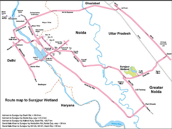
Surajpur wetland is situated near Surajpur village in Dadri Tehsil of District Gautam Budh Nagar under the Greater Noida Development Authority, Uttar Pradesh. The area lies between Latitudes 28°31.425'N and Longitude 77°29.714'E at an elevation of 184.7m msl. This Lake is located 800m from Delhi-Noida-Dadri road and 6km from Dadri Railway Station, 26 km from Delhi, 90km from Aligarh, and 24km from Noida and 3km from Greater Noida city, Uttar Pradesh.
General Information
State: Uttar Pradesh
District: Gautam Buddh Nagar
Forest Range: Gautam Buddh Nagar Forest Division
Region: National Capital Territory of Delhi
Protection Status: Reserve Forest
Habitat: Marshland
Coordinates: 28°31.425'North and 77°29.714'East
Biogeographic Zone: Gangetic Plain
Altitude: 184.7 msl.
Vegtation: Dry deciduous vegetation
Water source: Rainfall and Hawaliya drain or Tilapta Canal
Rainfall: Maximum rainfall- July to October, range- 400-500mm.
Climate: Tropical monsoon
Way to reach:
- New Delhi Railway Station to Surajpur-42km
- Hazrat Nizamuddin Railway Station to Surajpur-33km
- Old Delhi Railway Station to Surajpur-40km
- IGI Airport to Surajpur- 50km approximate
- Ashram to Surajpur via Dadri Road-28.5km
- Ashram to Surajpur via Noida Expressway-41.3km
- Sarai Kale Khan to Surajpur via Noida Link Road- 38km
Location Map


